Stuart Ross (Scotland) Ltd
Kaslo The Knoll, Roy Bridge, Inverness-

For Self catering in Fort William Click here

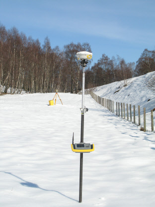
Trimble R8 GPS and Glonass
Surveying by satellite has improved immensely in terms
of reliability, speed and accuracy. While early generation kit required separate
radio, battery, receiver (in a cumbersome backpack with trailing cables) and antenna
components our Trimble R8 units are integrated all on the pole units with communication
between receiver and controller handled by bluetooth. It is the perfect instrument
for mountain side surveys. Previous limitations of poor SV coverage at certain times
of the day have virtually been eliminated with the inclusion of Glonass tracking
and has improved coverage in otherwise marginal areas. While there is a cheaper -
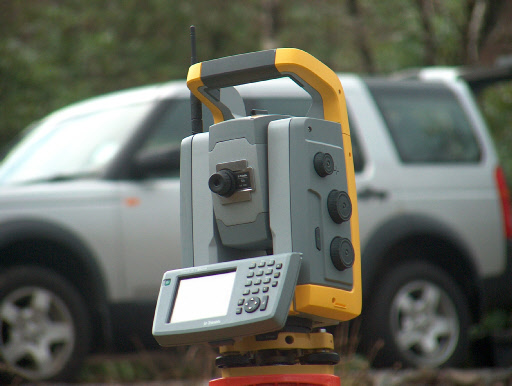
Trimble S6 Autolock RoboticTotal Station
There are several robotic alternatives
on the market and we looked at the all viable options. While it is far from cheap
the Trimble S6 tracks effortlessly and combines well with its own Trimble CE software.
It can be configured for automatic batches of face left face right rounds of angles
in traverse work, perform low density laser scans of quarry faces and in robotic
mode provides high productivity one operator solutions for detail survey and has
the unique capability to correct for minor shifts in level. Reference and stake out
data in dxf, various alignment formats, and complex 3D models, say for a proposed
land fill cell, can all be uploaded for site work. Measured coded survey data can
be previewed in plan view as the work proceeds and the code table can be be user
configured to precisely replicate settings on n4ce desktop software
In addition
the Scottish Trimble user benefits from excellent back up, service and support from
Survey Solutions Scotland.

GPS, Total Station or Integrated Surveying
The distinction between GPS and Total
Station has become less obvious (to the client) in recent years. While both sensors
are essentially a tool to locate a point in three dimensional space there is a place
for each technology often side by side within the same project.
SV (Space Vehicle) surveying requires a reasonably clear view to the sky all round
and when mounted on a hand held pole offers cm accuracy. There are no practical limits
on base line measurement. The total station remains a dumb instrument until supplied
with some initial set up data; is restricted to point to point line of sight over
land and consists of hundreds of complex precision optical and electronic components.
It does however provide mm accuracy in environments where this level of accuracy
is required.
Trimble’s implementation of both systems is remarkably efficient in
terms of surveyor miles and minimising the need for multiple tripod set ups. Integrated
surveying provides a convenient route to quickly establishing total station position
and orientation and allowing detail measurements to continue with all data held within
one field controller. GPS surveys invariably enclose some patch of remote land under
tree canopy. Previously the lead in work required to capture the 10 minutes of total
station data could consume a day alone. While the actual legwork may still be considerable
it does mean that the site work can be concluded much sooner.
Trimble S6 initialised with on the fly resection by integration with R8